
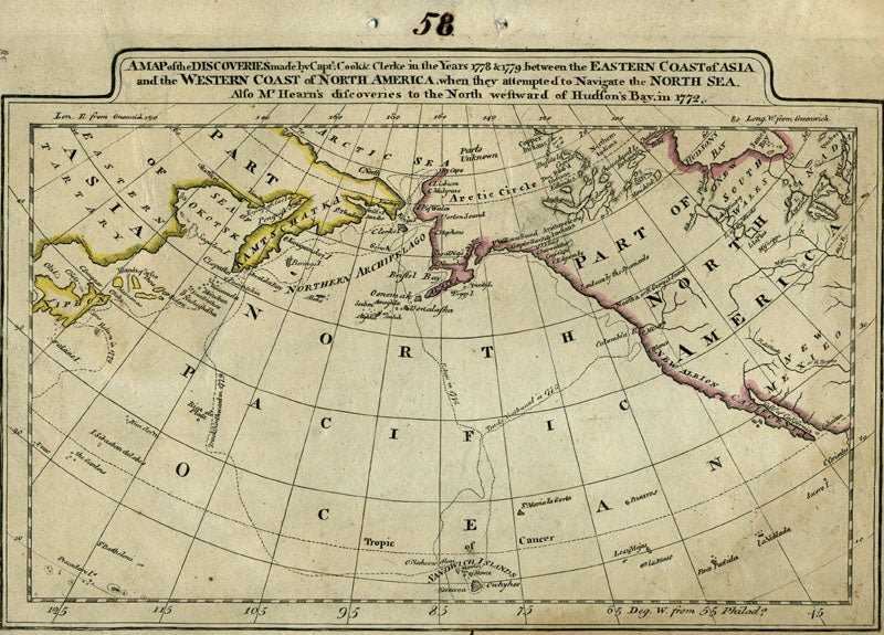
A Map of the Discoveries made by Capt.'s Cook & Clerke in the Years 1778 & 1779 between the Eastern Coast of Asia and the Western Coast of North America, when they attempted to Navigate the North Sea. Also Mr. Hearn's discoveries to the North westward of Hudson's Bay, in 1772.
Philadelphia: ca. 1798. The Columbia River is added to what is a later imprint of the 1795 edition of this early American map showing Cook's explorations of Hawaii and Alaska. Cary re-engraved a British map of 1784, and added changes reflecting American patriotism. Longitude is measured west from Philadelphia & Greenwich. "Engraved for Cary's American Edition of Guthrie's Geography improved." & "J.T. Scott Sculp." are erased from the printing plate, with some light traces left in the impression. Copper engraving, impression 292x197 mm, engraved surface 283x189 mm. The number "58" is scratched into the top corner as well as penned in the top margin. Rumsey #2542020 is a similar plate, although the sizes are a couple of millimeters different, possibly because this map is mounted on light card.
The chart centers on the Pacific Northwest Coast from the Gulf of California (the Baja Peninsula) to the Alaska Coast, Prince William Sound, Cook's River, the Bering Strait, the Aleutian Islands and Russian Kamtschatka. This edition includes the Columbia River, which earlier editions did not, and it first appeared on a British map of 1798, connecting it with the Missouri, from Vancouver's explorations. According to Fiske, Captain Gray, a New England trader of the ship "Columbia" charted it and shared his maps with Vancouver. The tracks of Capt. Cook in his ship “The Resolution” and Capt. Clerke in “The Discovery” are shown crossing the Pacific from Hawaii to the NW Coast & Kamtschatka. Capt. Clerke took over as Master of “The Resolution” after Cook's death in Hawaii in 1779. Samuel Hearne's discoveries to the north of Hudson's Bay are depicted, as well as the area where he located the Coppermine River in 1770. Hearne was the first white man to to cross overland from Hudson's Bay tracing the river to the Arctic Ocean. A faint water mark in the right side of the map, with early outline color on the continents. Very good condition overall. Item #14495
Price: $750.00