
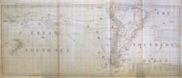
Chart containing the Greater Part of the South Sea to the South of the Line with the Islands Dispersed Thro' the Same.
London: 1775. Map published London 10th June 1775, printed in 2 sheets and joined to span the Southern Pacific ocean from west of New Zealand to east of South America. The vast masses of sea on the map are criss-crossed with the routes of explorers including Cook (1st voyage), Byron, Wallis, Bougainville, Anson, Halley & Narborough. Islands include Pitcairn Island, at the incorrect longitude of 133 degrees W; the "Imaginary Isles of Solomon" (Solomons); Otahiete (Tahiti); Marquesa of Mendoca (Marquesas) & Tierra del Spiritu Santu (New Hebrides). A very uncommon chart, with strong New Zealand and Antarctic credentials. Cook's discovery & circumnavigation of New Zealand is recorded, with his errors, only 2 years after the publication of Cook's own account. Freziers' ice islands are recorded, as are the close approaches of the Antarctic Circle by Cook & Anson. Tooley page 140 no. 1119. "Sayer was one of the leading publishers of geographical material in 18th century London. In 1775, he went into partnership with John Bennett and together issued a series of atlases and charts of most parts of the world." The northern border is the Amazon river, and in the south, Freziers' ice islands and the 60th degree latitude. Copper engraved map with original outline hand color, laid & watermarked paper, beautiful copper engravings of ships on the explorer's routes. Excellent condition with a few small chips in the margins, 111 X 45.5 cms (43 3/4 x 18"). Item #8381
Sold