
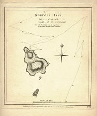
Norfolk Isle, Map.
London: Wm. Strahan, 1777. First edition. Map of Norfolk Island from James Cook's 2nd voyage. With note: "The pricked line shews the ship's track & the figures the depth of water in fathoms". There are 14 different figures showing the depths measured, along a zig zag path. Also with a compass rose, and a date on the track of Oct. 10th, 1774. Very good condition. Impression size: 8 7/8 x 8" on paper 13 1/2 x 10". On fabulous laid paper with impression marks, and very wide margins. Item #13422
Price: $175.00
See all items in
AUSTRALIA,
COOK, JAMES
See all items by James Cook