
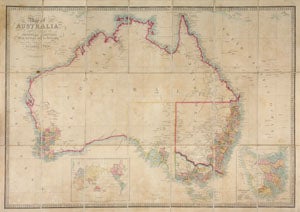
Map of Australia, Compiled from the Nautical Surveys, Made by Order of the Admiralty, And other Authentic Documents. By James Wyld. Geographer to the Queen. London. Published by James Wyld. Charing Cross East & Model of the Earth, Leicester Sq.
London: James Wyld, (1855). Dissected map mounted on linen. With green buckram end boards, and stored in a green cloth slip case with engraved title piece on cover and title on spine. With 68 counties in New South Wales; includes what was later to become Queensland; 25 counties in Western Australia (called "New Holland"); 6 counties in South Australia; 24 counties in Victoria; and 11 counties in Van Diemen's Land, all numbered. Three states have borders: New South Wales, Victoria and South Australia; inset of Van Diemen's Land lower right, insert of the world lower left. Gold discoveries are recorded in dark yellow. Pacific currents are denoted with arrows. Includes the expedition routes of Sturt (1845), Mitchell (1835), and Sturt and Hume (1829). Also includes "Mr. Cunningham was killed here" and "Milmeridun Burying Ground". Steel engraving with period outline color. 82 x 55.5 cm. Slight brown toning, otherwise in very good condition. The slip case dusty, rubbed at edges. Tooley 1385. Trove 23439229. Item #15627
Price: $1,250.00