
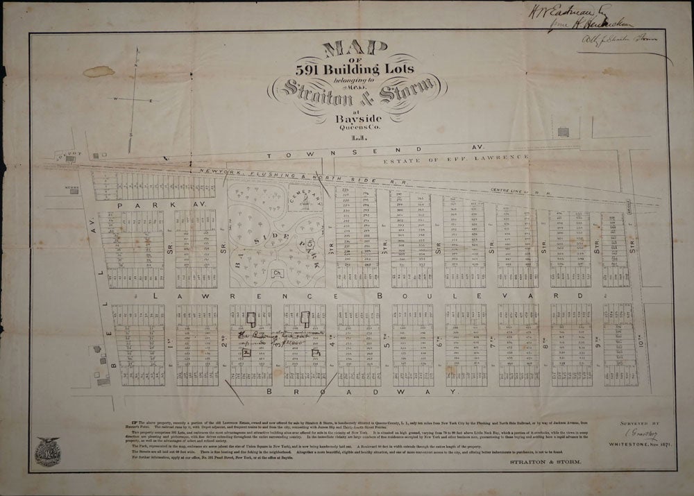
Map of 591 Building Lots belonging to Mess. Straiton & Storm at Bayside Queens Co. L. I.
New York: 1871. Handsome lithographed early map of Bayside, Queens building lots. From Townsend Avenue in the north to Broadway in the south, Bell Avenue to the west and 10th Street to the east, showing Lawrence Boulevard, Park Avenue and Bay Side Park, with the New York, Flushing & North Side R. R. line shown. Annotated by H. W. Eastman, and (H. Hendricksen) "attny for Straiton Storm", with notes at several lots between Lawrence Boulevard and Broadway stating "the buildings here including (illegible) cost upwards of $35,000". Straiton and Storm, with offices at Bayside and Pearl Street, New York, also apparently owned the largest cigar factory in America, Bayside's only industry at the time, built in the early 1870's, and standing at the corner of Bell Boulevard and 43 Avenue. With advertising text below the map, reading in part: "The above property, recently a portion of the old Lawrence Estate, owned and now offered for sale by Straiton & Storm, is handsomely situated in Queens County, L. I., only ten miles from New York City .... In the immediate vicinity are large numbers of fine residences occupied by New York and other business men, guaranteeing to those buying and settling here a rapid advance in the property... The Park ... embraces six acres (about the size of Union Square in New York), and is now being handsomely laid out". With lithographers seal printed at the lower left, Joseph Laing, Lithographer, Fulton St., New York. Surveyed by L Graethey, Whitestone, Nov. 1871 at the lower right. With slight toning at original folds, sml damp mark upper right, not in illustrated portion of map. 28 1/2 x 20" Item #16477
Price: $750.00