
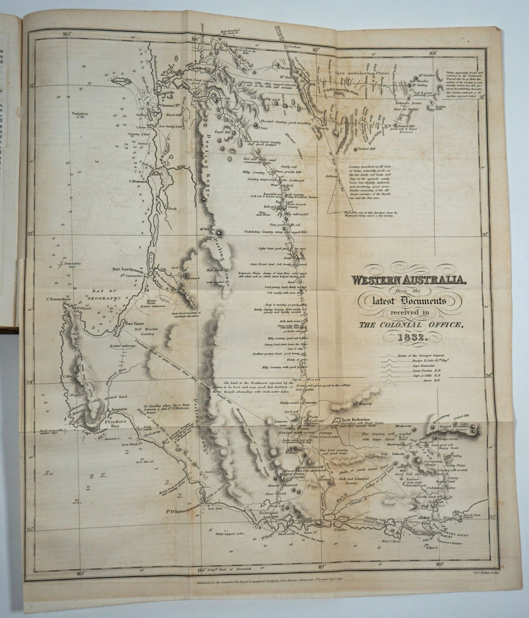
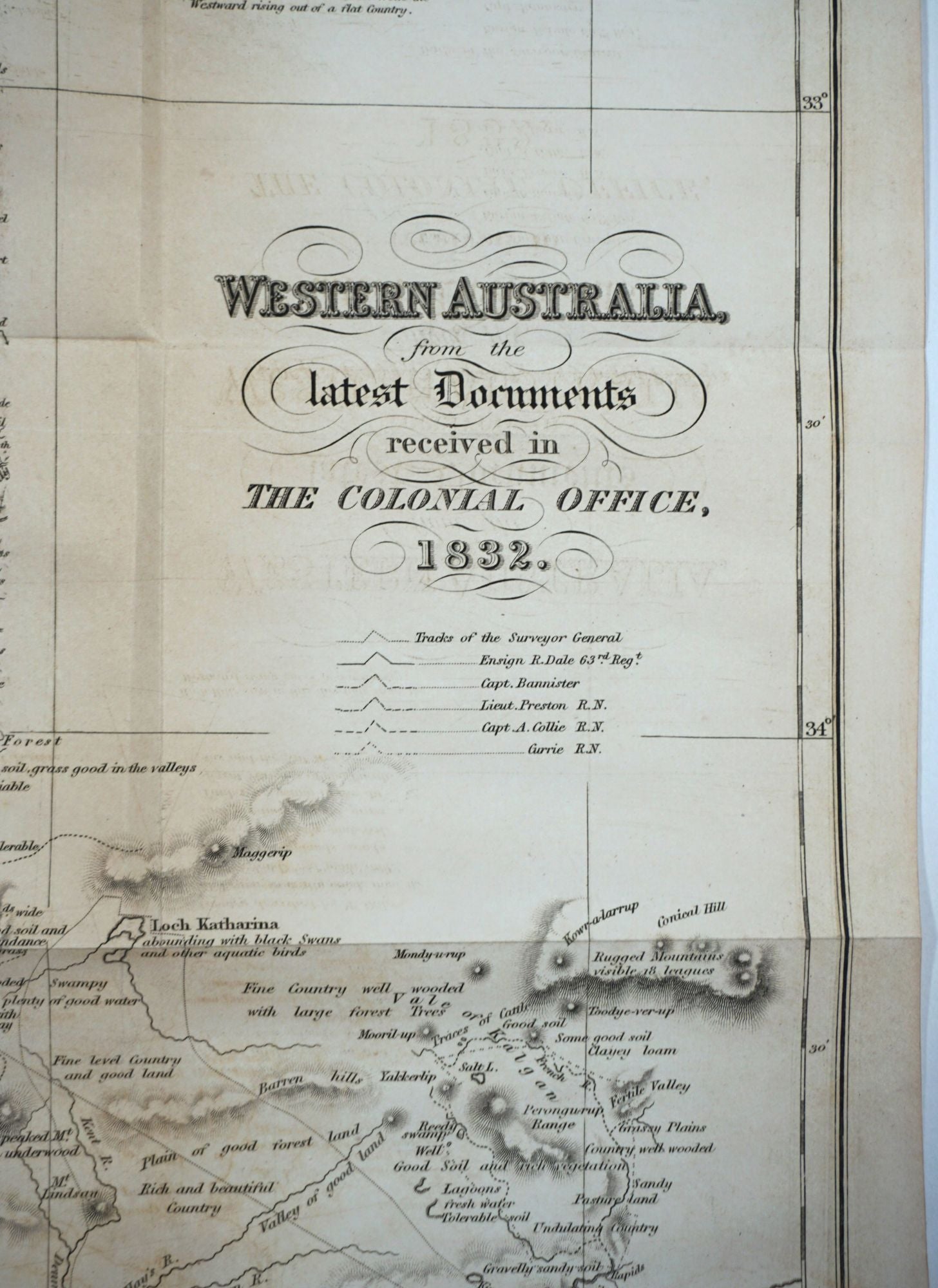
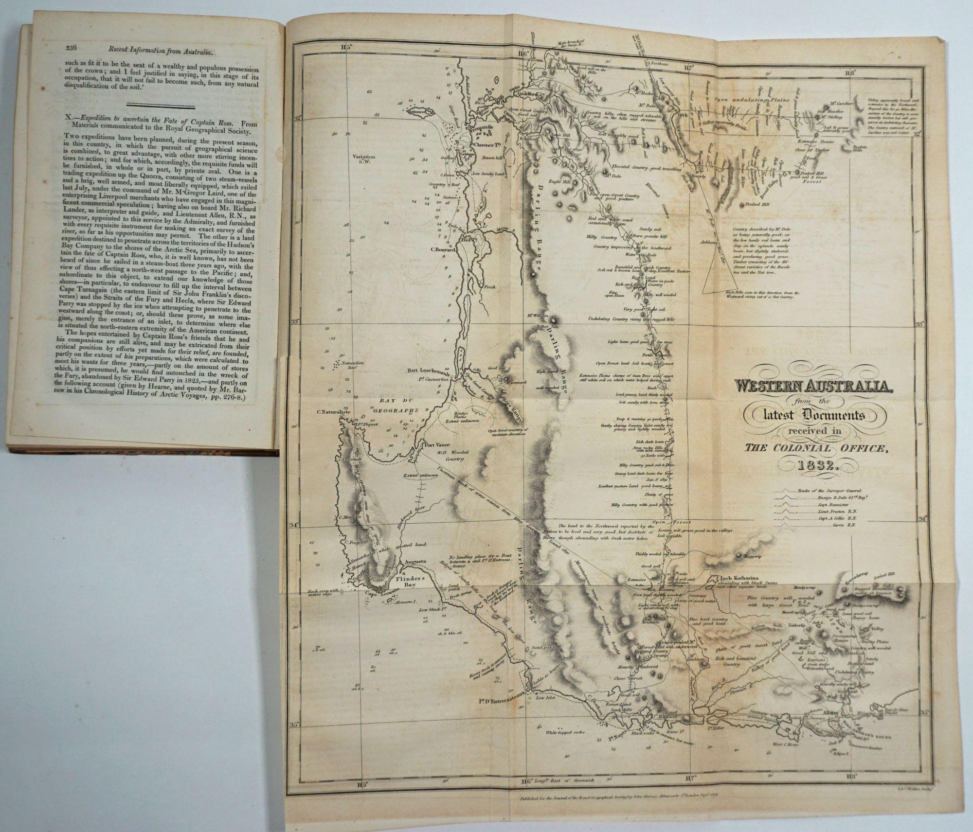
"Western Australia from the latest documents received by the Colonial Office, 1832"; map in the complete volume for the Journal of the Royal Geographical Society of London, 1832.
London: John Murray for the Journal of the Royal Geographical Society, 1832. First edition. Hardcover. The second volume of the esteemed Journal of the Royal Geographical Society, published in 1832, which includes one of the earliest printed maps of the West Australian colony, established as the Swan River Colony in 1829, just three years before publication, titled "Western Australia from the latest documents received by the Colonial Office, 1832." This attractive map extends from north of Perth to past Albany. The inland details comes from the explorations of Ensign Dale, Capt. Bannister, Lt. Preston, Capt. Collie and Currie, and all their tracks are marked and notated with sightings. This is a very early and attractively detailed map of the new settlement. The article that accompanies the map appears in Volume 1 (1831).
At this early date, the RGS did not list the maps in the volume, but this contains many: North Africa, the Egyptian Desert, Maldives, Mouth of the Ganges, Map of the South East portion of Australia shewing the progress of discovery in the Interior of New South Wales to 1832, New Zealand, Anegada, Upper Countries of the Nile, and West coast of Africa.
The several articles on recent information from Australia include 2pp of a dispatch from Gov. Stirling on young Western Australia, dated 2nd April 1832; 16pp on Eastern Australia by Lt. Col Dumaresq, Major T.L. Mitchell dating from Dec. 23, 1831 to Peel's River Feb 29, 1832; and 33pp, Brief View of the Progress of Interior Discovery in New South Wales by Alan Cunningham.
Contains among other articles: W. Martin Leake, Is the Quorra the same river as the Nigir of the Ancients; J. Wilkinson, Notes on a Part of the Eastern Desert of Egypt (map); Mr. Barrow, A Passage from Europe to Java; Captain J.E. Alexander, Notes of two Expeditions up the Essequibo and Mazaroony Rivers in 1830 and 1831; James Horsburgh, Some Remarks relative to the geography of the Maldives Islands; Lieut. Murphy, Account of the Cossyahs; Allan Cunningham, Brief View of the Progress of Interior Discovery in New South Wales; R.W. Hay, Notices on New Zealand; W.F.W. Owen, Particulars of an Expedition up the Zambezi to Senna; Robert Hermann Schomburgk, Remarks on Anegada; Adolphe Linant, Journal of a Voyage on the Bahr-Abiad or White Nile; Dr. C.F. Ph. Von Martius, (On the State of civil and natural rights among the aboriginal inhabitants of Brazil); Captain J.E. Alexander, Notices of the Indians in the interior of British Guiana; On the Hydrography of South America; Agriculture in Cashmere; Memoir descriptive of Prince's island and Anna Bom in the Bay of Biafra; On the Submersion by the Sea of part of Hayling Island near Portsmouth in the Reign of Edward III; Extract from a letter from Captain Fitzroy on the Abrolhos bank; communication between the Ganges and the Hooghly; recent information from Australia; Expedition to ascertain the fate of Captain Ross.
8vo, iv, [4], 339pp, (3). Inner hinges strengthened. The Western Australia map a little foxed with some light offsetting. 32.5 x 38 cms. Not recorded in Tooley. Original half brown gilt calf and marbled paper boards. The paper on boards is protected with clear adhesive plastic sheeting, with some loss to the marbled paper.
An important volume for Australian discovery, as well as an early one for the Royal Geographical Society. Item #21769
Price: $2,250.00