
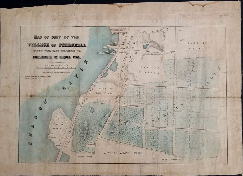
Map of Part of the Village of Peekskill exhibiting land belonging to Frederick W. Requa Esq.
New York: Snyder & Black Lithrs. 87 Fulton St. NY, 1850. A rare separately published map with period blue wash color showing the large estate of Frederick Requa of Peekskill NY, belonging to William Nelson, US Congressman and politician from Peekskill, with manuscript additions. These pencil additions at the top and bottom of the map show South Street, Depew Street and Union Street, with lot owners named Hunt, Smith and Coff and showing the Presbyterian and Methodist churches.
Frederick Requa was the second president of this Hudson River town (1839), a director of the Westchester Bank (first bank in the county, opened 1833) and a trustee of Peekskill Academy.
The map was the property of William Nelson, (1784 – 1869) a Peekskill lawyer, judge and politician who served for decades as district attorney for Putnam, Rockland and Westchester counties, and represented New York in the U.S. Congress from 1847 to 1851.
Nelson is widely credited with convincing his friend and colleague Abraham Lincoln to make a stop in 1861 on his inaugural journey to Washington DC at Peekskill's train station on Water Street (shown on this map). Here Lincoln gave a speech asking for support in the looming crisis, his only speech made to the people of Westchester County. The map is inscribed by Nelson in ink at the upper left: "This map belongs to Wm. R. Nelson".
This map shows the first full year in which rail service to Peekskill was available. The Hudson River Railroad opened this line on the 29th of September, 1849, to carry passengers the 40 miles between New York City and Peekskill. The map was surveyed and drawn by Thomas C. Cornell, Yonkers, on March 6th, 1850. Cornell was a civil engineer who worked for the Hudson River Railroad, and was responsible for the construction of the line from Spuyten Duyvil up to Dobbs Ferry, which was accomplished in 1850.
The Requa land is shown in 60 numbered lots, with the main property a large parcel extending west from the Hudson River to Washington Street and east, boasting a large dwelling house, multiple barns and outbuildings, an orchard and cider mill. F. W. Requa also owned a dock on the Hudson River, featuring a foundry building, and shown just south of the Peekskill Station.
The map extends from the Peekskill train station at Water Street in the north, to Bay Street and a private lane in the south, Washington Street in the east and the Hudson River in the west. Property owner names include J & N Frost, Z. Jones, John Henry, Joshua Weeks (one of the first settler families of Peekskill), Henry Reomer, Travis (arrived with the first settlers in the mid 1700s), and J. Lent. These families engaged primarily in agriculture, river transport, and small industrial and commercial businesses and profited from the location of the village on the main transportation route between New York City and Albany.
Streets include Grove Street, Hudson Street, Smith Street, "South Street or the Highland Turnpike", Requa Street, Orchard Street, Bay Street, William Street, and Washington Street.
Backed on linen, with some damage with loss to some old fold intersections. Slightly browned overall, some overall marking with water marks in the top margin, but generally good, with some manuscript penciling at the top and bottom of the map other roads not yet built. 27 x 17 1/2".
A rare map with an extraordinary Peekskill association. Good + overall. Item #23913
Price: $1,500.00