
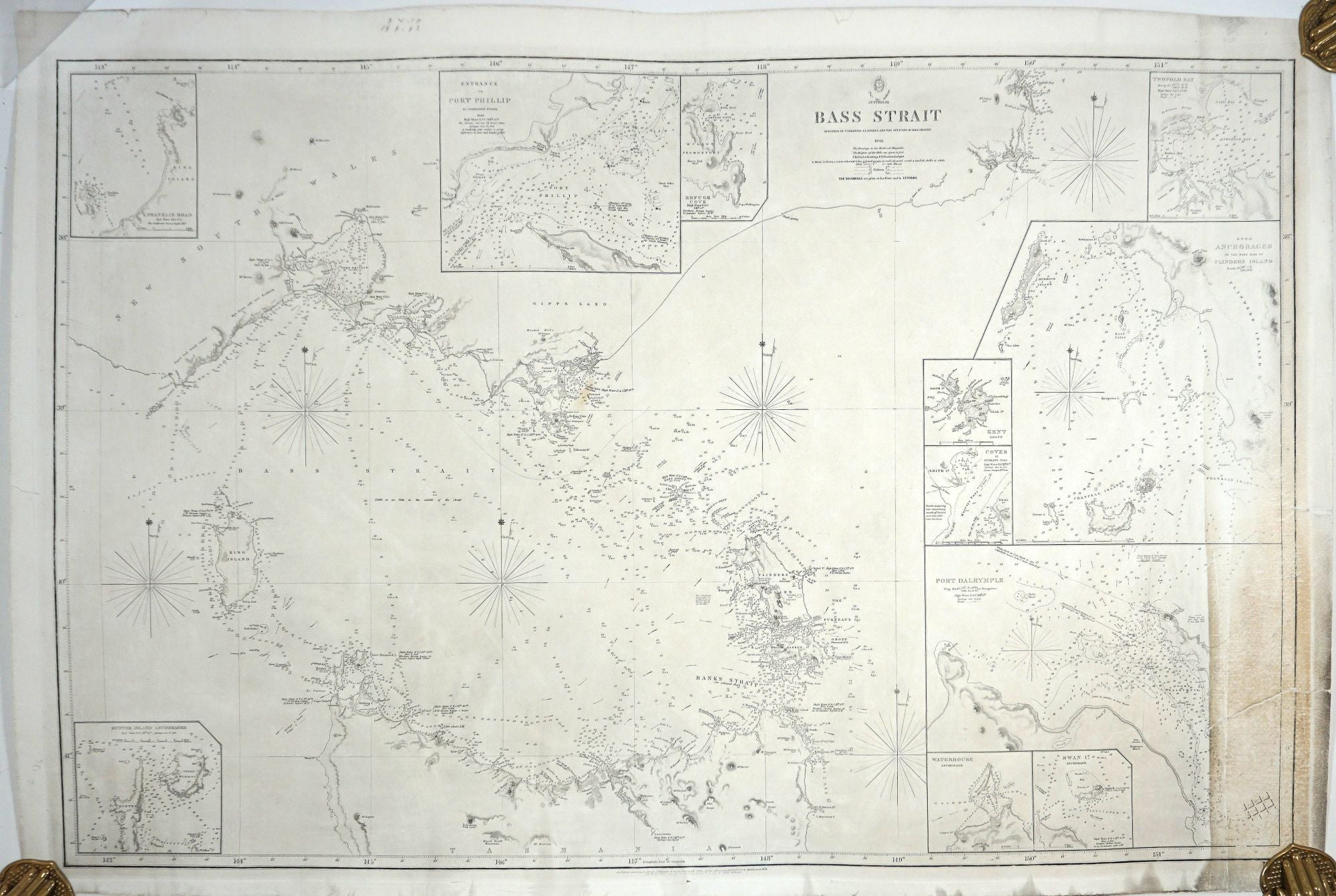
Bass Strait Surveyed by Commander J.L. Stokes and The Officers of the H.M.S. Beagle.
London: British Hydrographic Office, 1844, updated to 1851. 95x63 cm. Tooley. Maps. British Admiralty chart, updated to 1851. Tooley does not record this edition and it is not listed on Trove. Printed by the Admiralty just prior to the discovery of gold, it appears to be similar to 1844 first edition. The only additions so far located appear to be additional or changed colored markers in the entrance to the Port Phillip inset. The large format sea chart shows the South East portion of the Australian mainland and the north coast of Tasmania. Stokes (1811-1885) accompanied Darwin on the H.M.S. Beagle in 1837. He was employed by the British Hydrographic Office to chart parts of the Australian coastline. He was the author of "Discoveries in Australia; with an Account of the Coasts and Rivers Explored and Surveyed during the Voyage of H.M.S. Beagle in the Years 1837-38-39-40-41-42-43". Below the neat line "Published according to the Act of Parliament at the Hydrographic Office of the Admiralty. Dec'r 31st, 1844. Additions to 1851". Below that "Sold by R. B. Bate, agent for the Admiralty charts, 21 Poultry & Royal Exchange". "Price Two Shillings" appears at the top of the map.
See Libraries Australia ID 2855650; Tooley p. 346, no. 415 for the 1844 edition; no. 417 for Additions to 1856; no. 418 for Additions to 1858.
Early "Melbourne" is marked. There are 11 Insets, Entrance to Port Phillip, Refuge Cove (Wilson's Promontory), Twofold Bay, Good Anchorages on the Western side of Flinders Island, Port Dalrymple (Launceston), Swan Island, Waterhouse, Hunter Island Anchorages, Franklin Road, Kent Group, Coves in Murrays Pass. Light houses are recorded.
Complete with full impression lines and a margin. 381/2 x 241/4 printed size. Closed tear lower right into the Port Dalrymple inset. Lower right side dusty with rest of the map in very good condition. The chart is archivally restored and laid on linen. Very good overall. Item #25402
Price: $3,500.00