
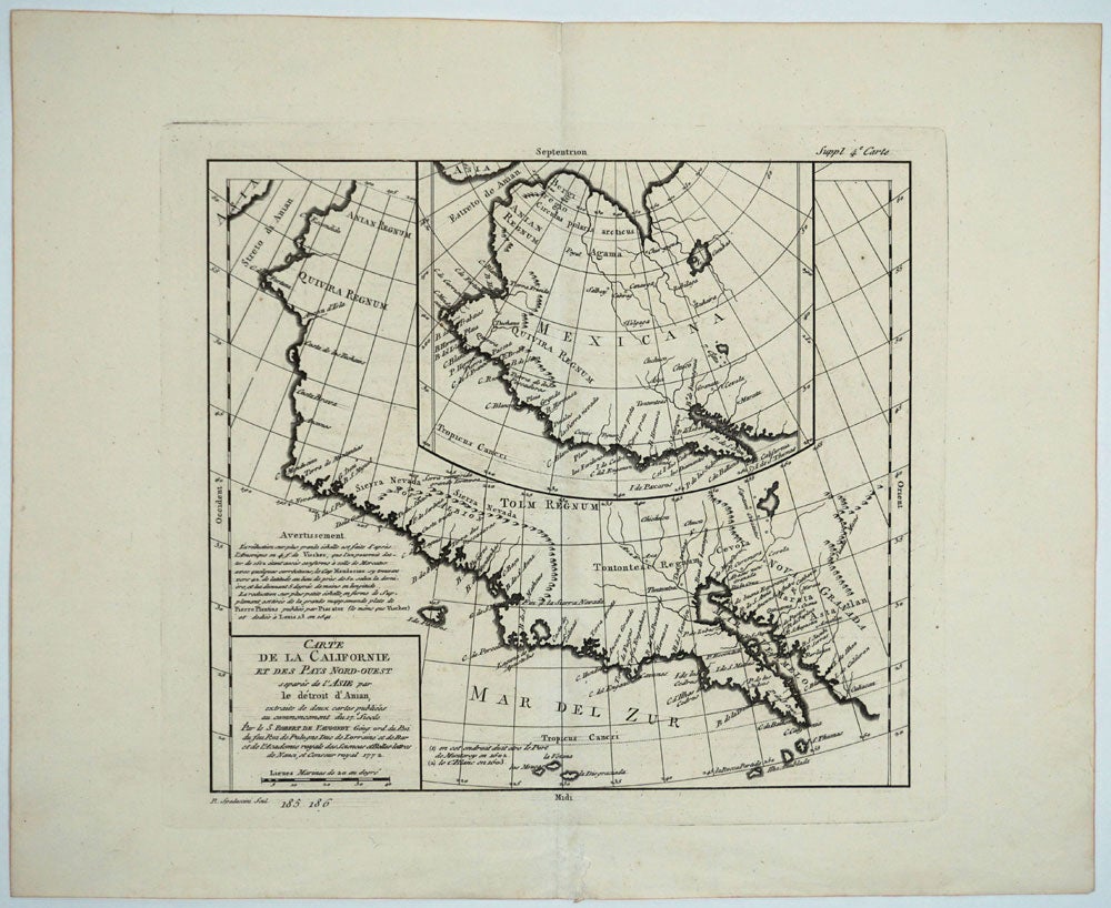
Carte de la Californie et des Pays Nord Ouest separes de l'Asie par le detroit d'Anian, extraite de deux cartes publiees au commencement du 17e. siecle / Par le S. Robert de Vaugondy Geog. ord. du Roi du feu Roi de Pologne Duc de Lorraine et de Bar et de l'Academie royale des Sciences et Belles-lettres de Nanci, et censeur royal 1772.
Paris: 1772 [1779?]. Maps. A map of comparative cartography of the West coast of North America, from the Straits of Anian to Cabo San Lucas and the southern tip of Baja California. Extracted from two maps, reportedly done by Vischer in 1612 and 1641, with information derived from earlier mapmakers. Both maps showing the fictitious Strait of Anian at the top; it was part of the legendary Northwest Passage, the long hoped for link of the Pacific and Atlantic Oceans, whose existence many explorers attempted to prove, and which James Cook challenged in his third voyage of 1778. The smaller inset map shows much more of the Strait, along with an open sea, making a suggestion of a Northwest Passage. The coastlines vary in both maps, with the smaller one listing important place names such as C. de San Francisco and los Farilones; while the larger shows the Bay of San Miguel (current day San Diego). The larger map showing a section of coast where the Sierra Nevada are drawn called "Nova Albion", which was explored and claimed for England by Sir Francis Drake; the smaller map showing the entire west coast area as "Mexicana". Image size: 12 1/2 x 11 3/4". Paper size: 19 1/2 x 15 3/4", black & white, as issued.
UBC records 3 copies in their collection, for 1772, 1777, and 1781. This copy has "upper margin " Suppl. 4e Carte: and lower margin "R. Spadaccini Scul. 185 186". UBC holds another Vaugondy map bearing the Spadaccini mark which it says "This atlas map removed from source: Robert de Vaugondy, Didier. [Recueil de 10 cartes...traitant particulierement de l'Amerique du Nord et des regions arctiques, d'apres les relations les plus authentiques depuis le commencement du 17 siecle, reproduites...]. 1 p.l., 10 fold. maps. 8. Livourne, 1779." Pedley #473; Wagner #632; Wheat # 159. Very good condition. Item #25865
Price: $275.00