
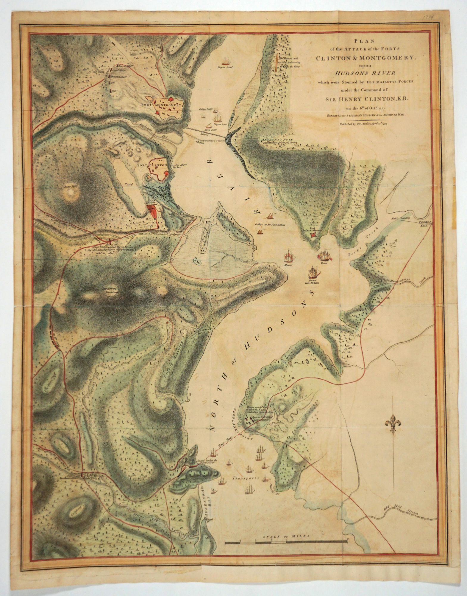
Plan of the Attack on Forts Clinton & Montgomery upon the Hudsons River, which were stormed by his majesties forces under the command of Sir Henry Clinton KB, on Oct. 6, 1777... Published by the Author, April 12th 1793.
London: J. Murray; J. Debrett; J. Kerby, 1794. First edition. This map illustrates the battles in the Hudson Highlands region during the Revolutionary War period, centering on the Hudson River from Haverstraw to just south of West Point. It clearly shows the location of the Boom (the chain) just north of today's Bear Mt. Bridge; Anthony's Nose; both Fort Montgomery & Fort Clinton battlements; Stony Point; Verplanks Point. Three British ships are named off Peekskill Creek, the Mercury, Tartar & Preston. At Manitou in Garrison is printed "Gen. Putnam with 2,000 troops endeavouring to cross the river."
This dramatic battle plan showing the British attempt to clear the Hudson River of the American rebel forces was first printed by William Faden in 1784 after the drawings of John Hills. General Clinton came out of New York with the intention of improving the deteriorating British position at Saratoga. The well-executed plan called for amphibious landings and encircling the American forts- all shown with much details about ships and troop movements on a map with excellent topographical accuracy. This copy of the map is a second printing in which Hills name is deleted. Hills was one of the most talented of the mapmakers in the British army. He served in America from 1777 until the end of the war and then remained to work as a commercial surveyor and draftsman.
Faden allowed Charles Stedman to use this map in his book, "History of the Origin, Progress & Termination of the American War", London 1794, considered by Sabin to be "The best contemporary account the Revolution written from the British side." Stedman himself was quite interesting, an American Loyalist. "Charles Stedman was educated in law at William and Mary College in Virginia. Like his father he remained loyal to the British crown, and on the outbreak of hostilities he was appointed commissary to the troops under the command of Sir William Howe. His knowledge of the German language assisted him both as interpreter with the German auxiliaries and afterwards as commander of a rifle corps of colonists from the Palatinate. He was twice taken prisoner, and sentenced to be hanged as a rebel, but on each occasion he managed to escape, once from the same prison that held the ill-fated Major André. He was also twice severely wounded. On the conclusion of peace in 1783 Stedman retired to England on the half-pay of a colonel, and was appointed to examine and settle the claims of the American loyalists. In 1794 his "History of the Origin, Progress, and Termination of the American War" was published in London and Dublin: it was well reviewed and remained the standard work on the subject for the next century. It was dedicated to Lord Rawdon, earl of Moira, his former commander-in-chief. Shortly after it appeared Sir Henry Clinton printed "Some Observations upon Mr. Stedman's History", which questions the author's accuracy on minor points" (J. S. Cotton, rev. Troy O. Bickham for DNB online) & Kate Hunter.
Copper engraved map, later hand color. Nebenzahl, Bibliography of Printed Battle Plans, #55 & ills. Stevens & Tree #21b.
Image 20 x 25 3/4" with 21 x 27" with margins, bottom margin added. Later hand color. Impression mark present on three sides, margin added on the bottom where impression mark is present on the left half. Sml. closed crack in right bottom margin restored. Overall in very good condition. The historian Harley comments that Stedman's work was "the most useful military text & maps of that war." Item #26888
Sold