
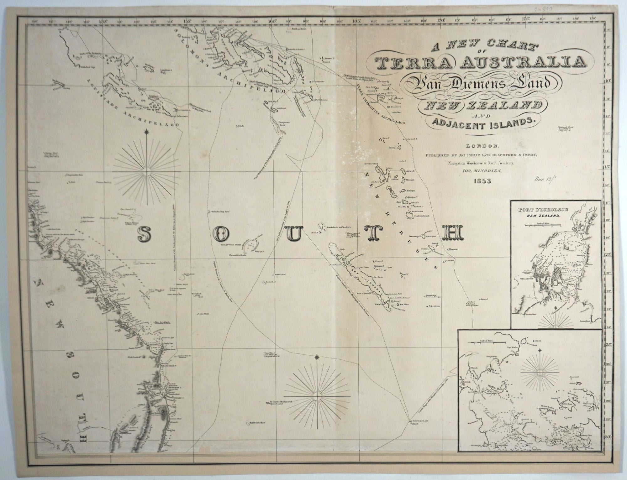
A New Chart of Terra Australia, Van Diemen's Land, New Zealand and Adjacent Islands. London Published by Jas Imray late Blachford & Imray, Navigation Warehouse & Naval Academy. 102, Minories. 1853 Price 12/ s.
London: Jas Imray late Blachford & Imray, 102 Minories, 1853. Reissue. Maps. A rare Imray chart dated 1853, using the name "Terra Australia", unrepresented in any public collections.
The only reference to any actual copy of this or any edition of this map we have located is in a private collection, the subject of an article by Greg Wood, in the Oct. 2018 issue of The Globe, published by the Australian and New Zealand Map Society. In it, he references "two rare and important charts", dated 1850 and 1851. The first is by James Imray, 'late of Blachford and Imray', using "Terra Australia" in the title. As contemporaneous Imray charts already refer to 'Australia', his sense was that the 1850 date notwithstanding, Imray hurriedly updated an earlier "now likely lost, chart by Blachford" catering to the rush to the newly discovered gold fields in Australia.
Not only are there no institutional copies located of the 1850 map, there are no copies of this 1853 map recorded on Trove, SLNSW, at the British Library nor the British Museum.
Hence, we offer this incomplete set of blueback charts, three of four charts of the Australian region, the Western Australian coast complete in two sheets and the North East chart including Queensland and the map title.
Oddly, in an article in the Adelaide Observer on 29 July 1854, a letter to the editor references this edition of the map, saying that they had omitted Kenn's Reef (the headline reads Kent's Reef, and today it is called Kenn Reef.) "As this omission may lead to similar disasters, it is necessary that the attention of mariners should be called to this subject." So, the map was available in Australia, but survivals are rare.
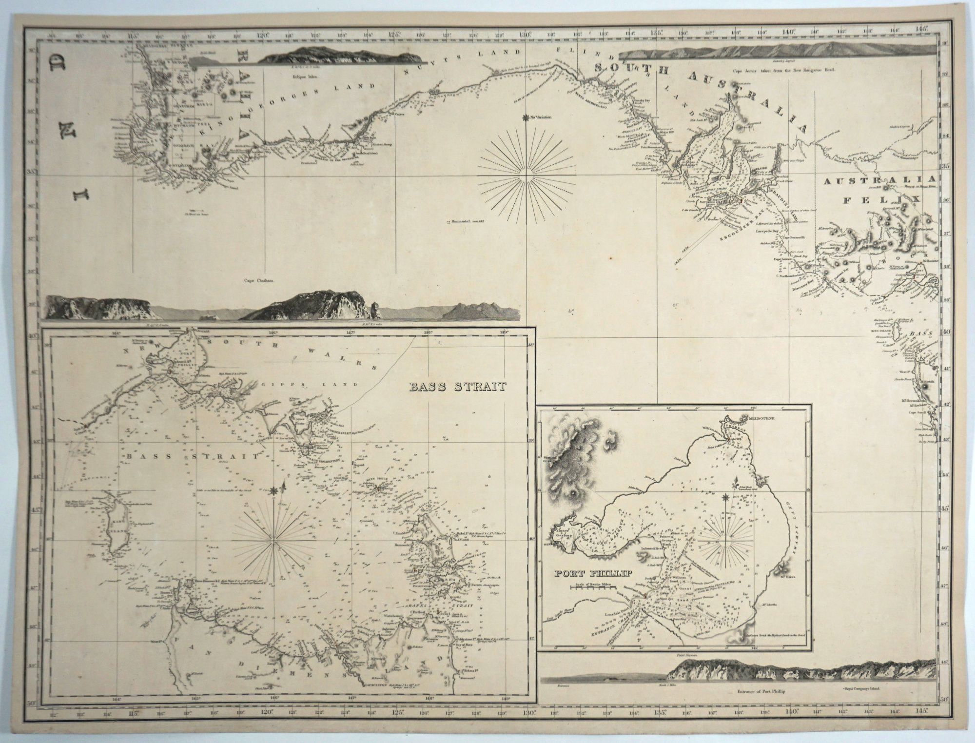
This chart was used on a voyage to Melbourne. This is indicated by a series of penciled numbers approaching the Victorian coast and on the inset of Bass Strait. The numbers indicate the date and the hours (24, 25, 26 followed 3, 10, 12, 4.) The numbering continues into the inset of Bass Strait. Unfortunately, the bottom right quadrant that would have covered New South Wales and part of Victoria & Tasmania is missing.
The top right chart features the East coast north of Coffs Harbour up to Pt. Tribulation, the Queensland coast. Brisbane is the only town marked on the map. Inland detail includes a dotted Darling River down to the northern tips of the Macquarie and Castlereigh Rivers. To the west is New Caledonia, with the New Hebudes(sic), Queen Charlottes Archipelago, Solomons Archipelago and the Louisiade Archipelago. The Pacific Ocean contains the printed title and the insets of Port Nicholson, New Zealand, Wellington with a town plan, and an untitled insert of French Polynesia. The price of 12 shillings is printed below the title.
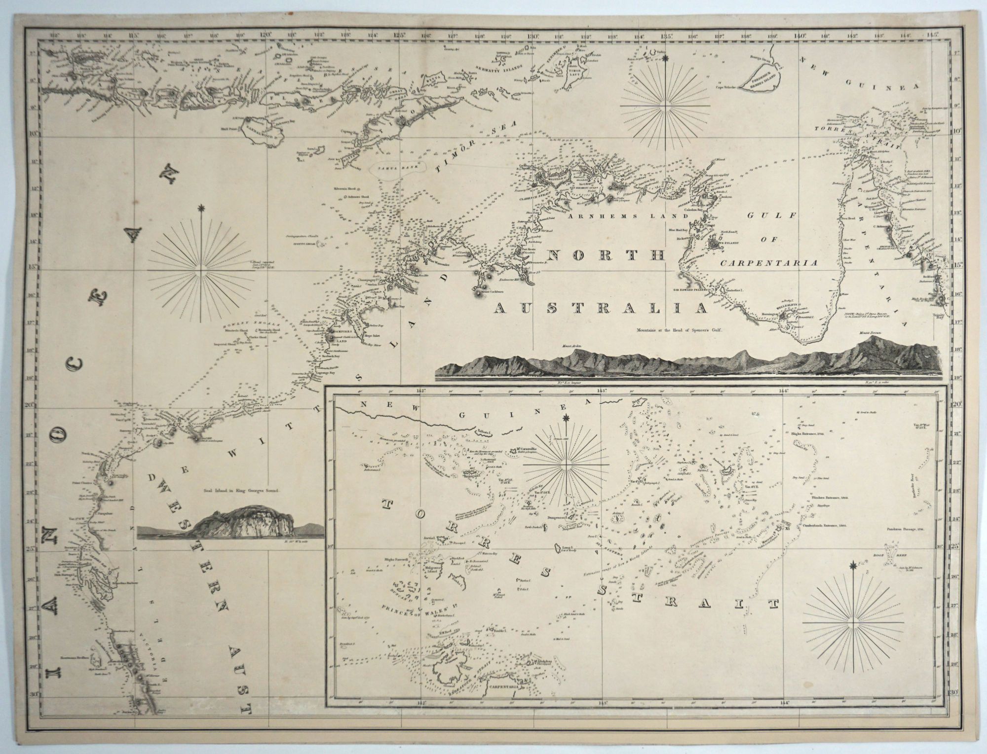
The two western charts encompass the whole of the West Australian coast. The top left chart runs along the entire north coast from far north Queensland to just north of Perth in the West. Australia's unexplored center is filled with a large inset of Torres Strait from Carpentaria to New Guinea with shoals and depth readings, where taken. Above this is an a coastal profile "Mountains at the Head of Spencers Gulf" and to the west, a coastal profile of "Seal Island in King Georges Sound". The chart ends at Jurien Bay.
The lower left quadrant chart traverses the coast from north of Perth to just beyond Melbourne. Western Australia has 22 counties and there are coastal profiles of Eclipse Isles and Cape Chatham. Below that in the blank sea is a detailed inset of Bass Strait featuring Melbourne and seven light houses indicated with red and yellow dots. Many depth soundings are included and the coast north of Wilson Promontory is a dotted line. The other inset is of Port Phillip, again with many depth soundings and the two light houses. Below is a coastal profile of the entrance to Port Phillip. The upper right has a coastal profile of "Cape Jervis taken from the new Kangaroo Head". Though dated 1853, the chart records Australia Felix and Van Diemens Land for Victoria (1851) and Tasmania (1851).
The four sheets were meant to be assembled together, and as such, there are no printed margins on two sides of each chart. The printed area of the Queensland / Title is 22 x 29"; Queensland/ NW W.A. 22 x 30"; SW W.A./ Victoria 23 x 30". Margins have been added with neatlines making all charts measure 23 1/2 x 30 1/4". The charts are backed on acid-free blue paper. The Title quadrant has slight discoloration right of center and a tiny triangle of loss in a blank area repaired. Overall, the charts are in remarkable condition. Very good condition. Item #26890
Price: $8,500.00