
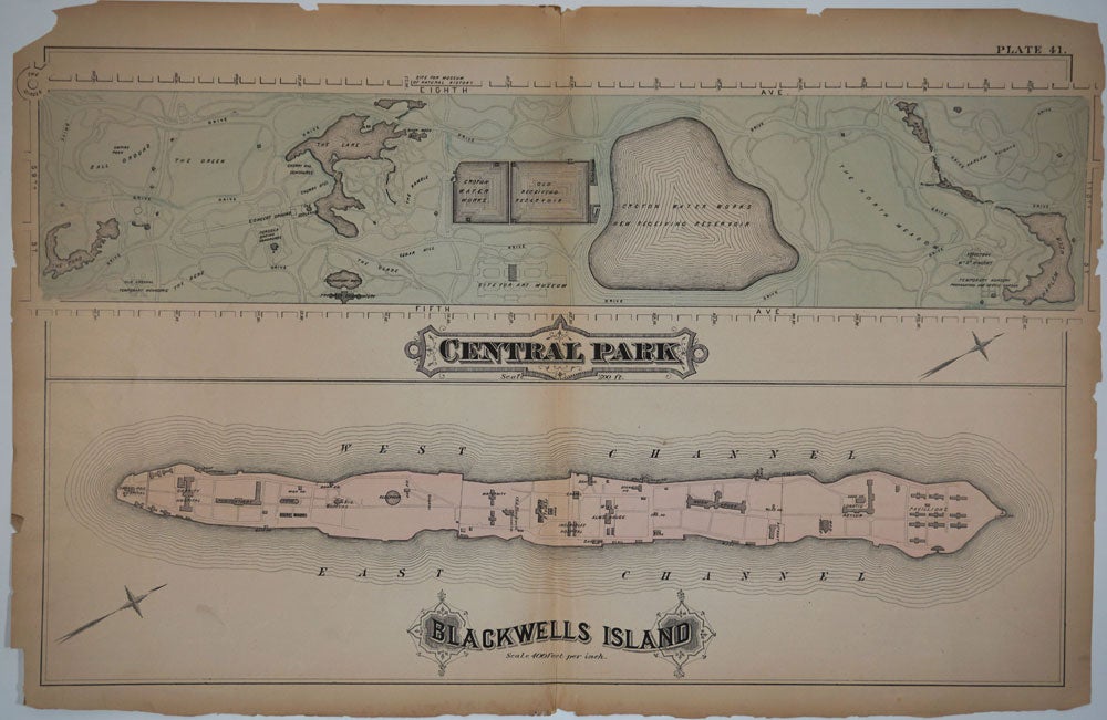
"Central Park. Blackwells Island". Maps printed on 1 sheet.
New York: G. W. Bromley & E. Robinson, 1879. Large color lithographed map of 2 New York City landmarks, Central Park and Blackwell's Island, now known as Roosevelt Island.
The dominant feature of the Central Park map is the enormous amoebae shaped "Croton Water Works New Receiving Reservoir" which is flanked by 2 other Croton Water Works reservoirs. Along the bottom of the Park we see "Site for Art Museum" (the Metropolitan Museum of Art didn't move to this site until 1880). On the west side of the park is "site for Museum of Natural History".
At the southern end of the Park the Ramble, the Cherry Hill Concourse, the Concert Ground, the Casino Concourse, the Green, the Ball Ground, the Pond and the Temporary Menagerie are located. The park extends from 110th Street to 59th; at its northern boundary is a lake marked "Harlem Meer".
Blackwells Island sites include the Charity Hospital, Penitentiary, Maternity, Old Blackwell Mansion, Female Alms House, Incurables Hospital, Male Alms House, Work House, Lunatic Asylum, and Pavilions. In 1879 the Lunatic Asylum was soon to be the topic of Nellie Bly's investigative reporting in 'Ten Days In A Madhouse', (1887) an expose written after Bly had herself committed to the institution in order to reveal its horrific conditions.
Plate 41 of Bromley's 1879 city Atlas. See David Rumsey Collection, Image No: 2597042. P15989; Haskell 1316; Nestler p106.
27 3/4 x 18 1/4". Chipped at edges, especially right edge, with no loss to image. Good + condition. Item #24445
Price: $450.00