
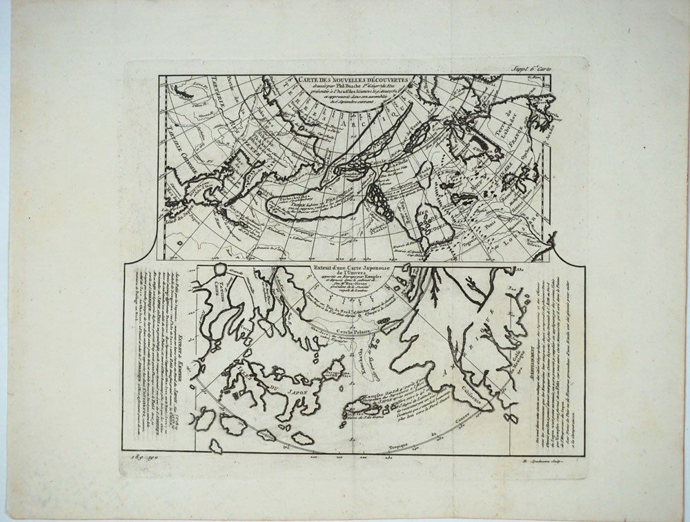
Carte des Nouvelles Decouvertes // Extrait d'une Carte Japonoise de l'Univers.
Livourne: 1779. Maps. A map of Asia, Canada, Japan and the Arctic regions, with two maps on one sheet. The upper map shows the European view of the northern Pacific, showing western North America from New Orleans west with a clearly depicted Mer de l’Ouest, to Kamchatka and northern Japan. The lower map shows the Japanese perception of the same region, with very sketchy and inaccurate features in North America and a larger showing of the Japanese islands. The Japanese map has no depiction of Alaska.
Copper engraving with two maps on one sheet. Includes text. Upper margin: "Suppl. 6e carte." Lower margin: "189 190"; "R. Spadaccini Sculp." This conforms with the edition at the Univ. of British Columbia mccormick_174. According to UBC "This atlas map removed from source: Robert de Vaugondy, Didier. [Recueil de 10 cartes...traitant particulierement de l'Amerique du Nord et des regions arctiques, d'apres les relations les plus authentiques depuis le commencement du 17 siecle, reproduites...]. 1 p.l., 10 fold. maps. 8. Livourne, 1779."
The title translates - Map of new discoveries, prepared by Phil. Buache, the King's Geographer, presented to the Academy of Science August 9, 1752 and approved in its meeting on the 6th of September following. (and) Excerpt from a Japanese map of the universe brought to Europe by Kaempfer and deposited in the cabinet of the late Mr. Han-Sloane, president of the Royal Society of London.
The map also appeared in a supplement to Diderot and d'Alembert's "Encyclopédie" (without the lower margin text.)
Printed area measures 12 1/2 x 14", on paper 15 3/4 x 20 1/4". Very good overall, with some unevenness in paper production causing the lower margin to look somewhat mottled. Item #25866
Price: $250.00